MS in Geospatial Intelligence
Geospatial intelligence informs and influences policy, military, diplomatic, environmental, and disaster relief and recovery decisions and operations by governments at every level. Increasingly, in non-governmental sectors, it is informing and influencing public health, business, infrastructure, energy, regulatory, and advocacy decisions.
The MS in Geospatial Intelligence program unites three fields of study: the history of geospatial intelligence; the science and mathematics of digital geography and its related databases; and the art of converting geospatial data into written, spoken, and visual intelligence. Students analyze historical intelligence examples to understand the development of the concepts and practices behind collection, analysis, reporting, and technology. They also focus on current challenges in the profession, among them the analytics and technology needed for the volume of current and future collection, the challenges of new sensors, and the development of new non-governmental geospatial communities.
Admissions Criteria for all Advanced Academic Programs
PROGRAM-SPECIFIC REQUIREMENTS
In addition to the materials and credentials required for all programs, the Master of Science in Geospatial Intelligence program also requires:
- A resume or curriculum vitae
- A statement of purpose: A 500-word statement of purpose in pursuing geospatial-intelligence studies.
- Two recommendations: Under “Recommendations,” include the contact information for two recommenders. Professors or supervisors should verify academic and professional accomplishments. They will be automatically emailed information to access the system. They can then complete and upload their recommendation form.
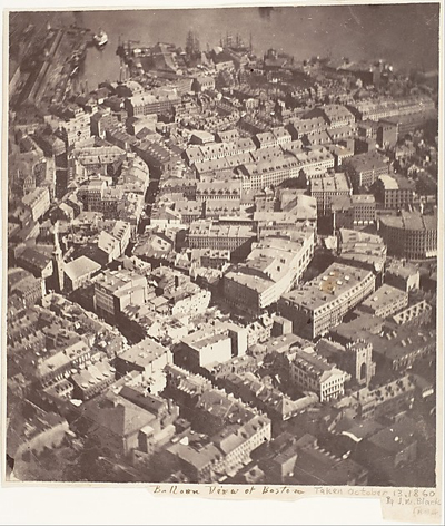
- A geospatial writing sample: Complete and submit a two- to three-page geospatial writing sample that compares and contrasts this 1860 image with a modern Google Earth image of the same location. Both images show the north end of Boston, Massachusetts. A common reference point is the Old South Church, now called Old South Meeting House, which is near the left-hand side at the center of the 1860 balloon view of Boston. Examine the map and the Google Earth image to identify and analyze what visibly remains on the Google Earth image from the 1860 image. The writing sample should be double spaced, using either 11-point Calibri or Arial font. The writing sample should include:
- Discussion of the most significant changes and similarities between the two images and why you think they are important. Please indicate how you decided what was significant about the changes and the similarities you have noted. In the last paragraph, please indicate the next steps you would take if you wanted to learn more about these two images. Use evidence to back up your assertions, and cite your sources using academic conventions.
- Two measurements you have recorded, either as you are working or after you are done. Submit the two measurements with your analysis. The measurements will not be used for any individual performance measurement, only to illustrate an enduring challenge for all geospatial analysis that will be covered throughout the introductory course and the entire program. The measurements are:
-
How long did you spend examining the images (looking and thinking)?
-
How long did you spend writing up the results (writing and thinking)?
-
Program Requirements
Students complete 12 courses to earn their degree:
- Eight required core courses
- One customizable core course
- Three elective courses
| Code | Title | Credits |
|---|---|---|
| Core Courses - Required: | ||
| AS.472.600 | Introduction to Geospatial Intelligence | 3 |
| AS.430.601 | Geographic Information Systems (GIS) | 4 |
| AS.430.603 | 4 | |
| AS.430.604 | Spatial Analytics | 4 |
| AS.473.600 | The Art & Practice of Intelligence | 3 |
| AS.430.612 | Cartographic Design and Visualization | 4 |
| AS.472.613 | Geospatial Law and Ethics | 3 |
| AS.472.800 | Capstone in Geospatial Intelligence | 3 |
| Core Courses - Customizable: | 3 | |
| Select one of the following: | ||
| Technical Collection of Intelligence | ||
| Remote Sensing: Systems and Applications | ||
| Electives | 9 | |
| Select three of the following: | ||
| Web GIS | ||
| Programming in GIS | ||
| GIS and Spatial Decision Support Systems | ||
| Spatial Data Management: Quality and Control | ||
| Geospatial Ontologies and Semantics | ||
| Advanced Topics in Remote Sensing | ||
| Big Data Analytics: Tools and Techniques | ||
| Advanced Python Scripting for GIS | ||
| Web Application Development | ||
| Artificial Intelligence and Machine Learning in Geospatial Technology | ||
| Drones in Geospatial Decision Making | ||
| GIS for Emergency Management | ||
| Climate Change and National Security | ||
| Machine Learning Methods and Applications | ||
| Energy, Security, and Defense | ||
| Commercial Imagery and the Impact of Small Satellites | ||
| Analyzing Social Media and Geospatial Information | ||
| Geospatial Analysis: Communicating with Multiple Audiences | ||
| Applied Critical Thinking and Analysis | ||
| Intelligence Ethics | ||
| Intelligence Analysis | ||
| Total Credits | 40 | |
Learning Outcomes
The MS in Geospatial Intelligence weaves the history, science, mathematics, and art of geospatial analysis into a program that will enable its graduates to lead and shape this rapidly-growing intelligence discipline. The program combines recognized faculty with extensive geospatial experience and publications, an interactive and online curriculum, and the research resources, tools, and opportunities for its students to:
- Understand the history and evolution of geospatial intelligence and its enduring challenges.
- Develop the habits of mind and the conceptual framework to thrive as analysts, researchers, program leaders, and managers in the geospatial communities.
- Employ the appropriate mathematical models and scientific sensor knowledge necessary to design advanced commercial geospatial collection management for big data and small data problems, and to design geospatial databases for complex issues.
- Develop analytic processes and products as well as demonstrate the ability to communicate geospatial information and analysis accurately and persuasively in writing and briefing.
- Produce original research on the history and methodologies of geospatial intelligence.